Guides · Using the map
How to use Google Earth for a land search
Three versions, one globe. This covers the controls you will actually use while reading a map of land, and skips the rest.
Updated September 6, 2026
Google Earth is free, and every Prepared Ground layer opens in it. Nothing here needs a paid account, a plugin, or GIS software. If you have used Google Maps you already know most of it; the differences are that Google Earth tilts, it shows terrain, and it can load files of your own on top of the imagery — which is the whole point.
Which Google Earth
There are three, and they all open the same files.
| Version | Where | Best for |
|---|---|---|
| Google Earth (web) | earth.google.com in Chrome, Edge, Firefox or Safari | A first look. Nothing to install; sign in with a Google account. |
| Google Earth Pro (desktop) | Free download for Windows, Mac and Linux | Long sessions. The layer tree is easier to work with and it handles big files more comfortably. |
| Google Earth (mobile) | App Store / Google Play | Checking something in the field. Too small a screen for real filtering. |
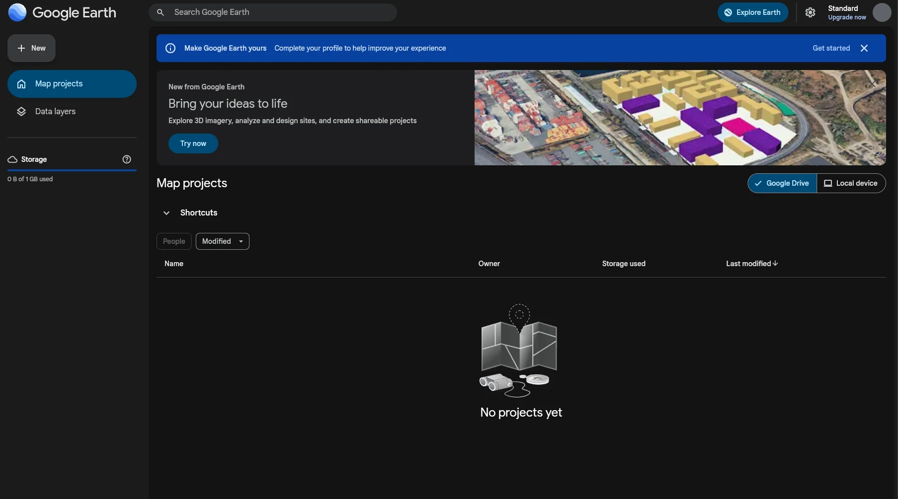
Start in the browser. Signed in, it opens on Map projects — the list of maps you have built, empty the first time — with a New button top left for starting one. Projects save to Google Drive as you work (1 GB on the free plan), or to your own machine if you switch the list to Local device.
If you find yourself spending hours toggling layers, install Pro — nothing in the set requires it, but its Places panel makes juggling several layers less fiddly.
Not Google Maps. Google Maps and its My Maps feature are a different product with
their own file limits, and they will choke on these layers. The New menu in Google
Earth also offers Open Google My Maps; that is the wrong door. If a .kmz opens in
something that looks like Google Maps, you are in the wrong place.
Moving around
- Pan: drag the globe.
- Zoom: scroll wheel, pinch, or the + / − buttons in the corner. Double-click zooms in on that spot.
- Tilt and rotate: hold Ctrl (or Shift) while dragging, or use the compass control in the corner.
- Back to north-up, top-down: click the compass, or switch the 2D/3D toggle to 2D.
- Keyboard: arrow keys pan, + and − zoom.
For reading overlays, stay top-down and mostly zoomed out. The layers are drawn at county scale; tilt and 3D buildings only get in the way until you are looking at one specific piece of ground.
Finding a place
The search box takes anything: a county (Baxter County, AR), a town, an address, or
coordinates in decimal degrees (36.28, -92.36). Google Earth flies there and drops a
marker, which you can clear afterwards.
County names repeat across states — there are 31 Washington Counties — so include the state.
The base map
The imagery underneath is what Google Earth draws by default. Two settings matter:
- Map style (web: the Map Style panel; Pro: the Layers panel, bottom-left). Turn on borders and labels so county lines and town names show through the overlays, and turn off 3D buildings, photos and animated clouds so they do not. The web version’s Clean preset with borders and labels added is about right.
- Terrain. On by default and worth keeping: a county that reads well on paper can turn out to be all ridge.
Where your files go
Anything you import lives in a panel on the left:
- Web: inside a project, the Map contents panel. Each imported file is a folder, with the folders inside it nested underneath. Every item has an eye icon: click it to show or hide that folder, and hidden ones are greyed out. Expand a folder with the arrow to its left.
- Pro: the Places panel. Imported files land under Temporary Places until you save them to My Places. Expand a folder with the triangle, tick the box to draw it.
The Prepared Ground layers arrive hidden, so the first thing to do after an import is show the top folder. Importing a KML file goes through the steps for each version.
Clicking things
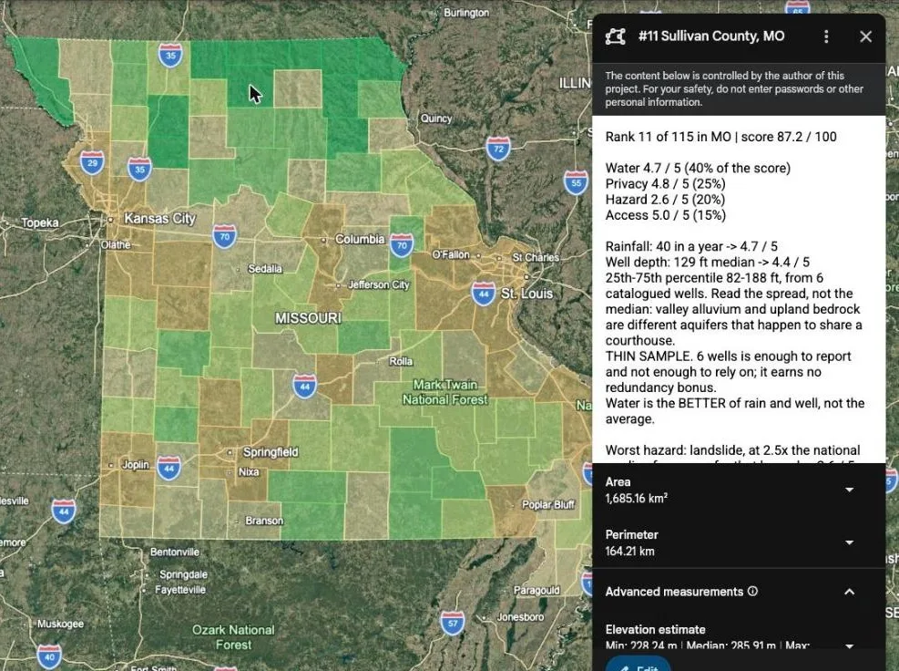
Click a shaded county and a balloon opens with whatever that layer knows about it — for your State Screen, that is the county’s score, its four sub-scores and the raw numbers behind them. Close it with the ×. With several layers drawn on top of each other the click lands on the topmost, so hide the one you are not asking about.
Measuring
The ruler measures distance and area on the ground. Web: the ruler icon in the toolbar. Pro: Tools → Ruler. It is the fastest way to answer “how far is that from the nearest town” for a parcel you are already looking at, and it is more honest than a straight line from a county centroid.
Historical imagery and Street View
Both versions can show older imagery of the same spot, which is how you find out that the clearing was a burn scar three years ago or the creek changes course. Street View — drag the small figure onto a road — shows the road itself, which for rural land is a fair proxy for how far the county’s maintenance reaches.
Saving your work
- Web: a project saves itself to Google Drive as you work — the title bar says Saved to Google Drive — and is listed under Map projects next time you open Google Earth. Click the title to rename it from Untitled map project to something you will recognise. A project kept on Local device instead stays in that browser only.
- Pro: File → Save → Save My Places, or right-click a folder and save it. Pro will also ask on exit whether to keep anything still under Temporary Places.
What it cannot tell you
Google Earth shows you the surface, at whatever date the imagery was flown. It does not know parcel boundaries, deeded access, flood zone, or whether there is water on the ground, and neither do the layers. They tell you where to look. Everything after that is your own due diligence.
Next: Importing a KML or KMZ file, then the filtering guide.