States · Maryland
Maryland: every county, ranked.
The State Screen scores all 24 counties in Maryland from 0 to 100 against each other on the four things a homestead can't do without: water, privacy, hazard exposure and access. Nothing is screened out. How the score works.
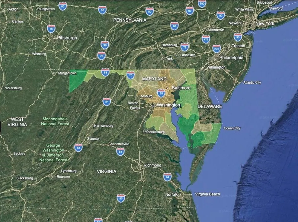
Top five counties
- Garrett County
- Somerset County
- Dorchester County
- Caroline County
- Queen Anne's County
In order, without their scores. Every county's score, its four sub-scores and the raw numbers behind them are in the free map.
Free for an email address: a Google Earth file with every county clickable.
What the map says about Maryland
Rain is rarely the problem in Maryland: the median county gets 47 inches a year, and the wettest 49.
Across Maryland, the typical well is 152 ft deep. In 50% of its counties the median well is 150 ft or shallower; in 0% it is 400 ft or more.
The hazard that scores worst most often is hurricane, in 17 of 24 counties.
Every county in Maryland sits inside a metro commuting ring, and the median one is 4 miles from a town of 5,000.
These are counties, not parcels. A good score says the region has the water, the quiet and the hazard profile; it says nothing about a particular piece of land's flood zone, access or water source.
Law, tax and connection in Maryland
Read from the Maryland rows of six layers in the complete map. Law is current to August 2026 and changes; check it with the state before you rely on it.
How strict are Maryland's gun laws?
62 of 100 on the Gun Laws layer, which scores twelve restrictions. In force: Permit or licence required to buy or possess; Semi-automatic rifle ('assault weapon') ban; Magazine capacity limit; Background check on private sales; No permitless (constitutional) carry; Waiting period; Red flag / extreme risk order law.
How regulated is homeschooling in Maryland?
48 of 100 on the Homeschool Laws layer, which scores seven requirements. Required: Standardised testing or professional evaluation; Written notice of intent; Attendance records or a portfolio; Mandated subjects. Scored on the local-school-system route, which is Maryland's own: notice fifteen days ahead, a portfolio of materials, the enumerated subjects, and a review by a school-system representative you must agree to permit, up to three times a year. The alternative under COMAR 13A.10.01.05A is supervision by a school or institution operated by a bona fide church organisation - take it and everything falls away except the fifteen-day notice, putting Maryland at 1.0. That is a private supervisor, so this layer does not score it.
Does land in Maryland come with its water?
Maryland is not one of the 18 states where water is allocated by prior appropriation, so the Water Rights layer leaves it unshaded. Water law still varies; ask about the well and any surface water before you buy.
What does land cost to hold in Maryland?
The median county's effective property-tax rate is 0.94% of value, from 0.66% in Talbot County to 1.48% in Baltimore city. At the median rate a $250,000 property pays about $2,350 a year.
How much of Maryland is open public land?
4.3% of Maryland's land area is public land open to the public. Adjoining public land does not mean a legal right to cross it; confirm recorded access on any parcel.
Can you get online in Maryland?
91% of Maryland's households pay for broadband. That is what people buy, not what is available; for a specific road, ask the local electric co-op.
Data release 2026-10-02. Sources: rainfall NOAA 1991–2020 Climate Normals; well depth USGS NWIS national groundwater site inventory; property tax Census ACS 2023 5-year, tables B25103 and B25077; public land USGS PAD-US over Census TIGER land area; broadband Census ACS 2023 5-year, table B28002; gun, homeschool and water law from state statute.
Then make it yours
The State Screen is one opinion of what matters. The complete map is 35 layers you switch on and off to suit your own search — wildfire, water rights, radon, well depth, state gun and homeschool law, distance from the cities, military sites and more — across the US, Canada and Mexico.